Satellite instruments can either detect the thermal emission during a fire or the burnt area after. The latter are known as "burnt area", "burnt scar", "burnt pixel" or "fire affected area", while the first products are referred to as "hot spots", "active fires", "fire pixels" or "fire counts" (Kaiser et al., 2009).
Active fire detection from satellites takes advantage of the fact that as target temperature increases radiance increases faster at the shortwave end of the spectrum when compared to the long-wave end. By using two atmospheric window spectral channels, such as the 3.9 and 11μm, fire locations and characteristics can be determined (Dozier et al., 1981).
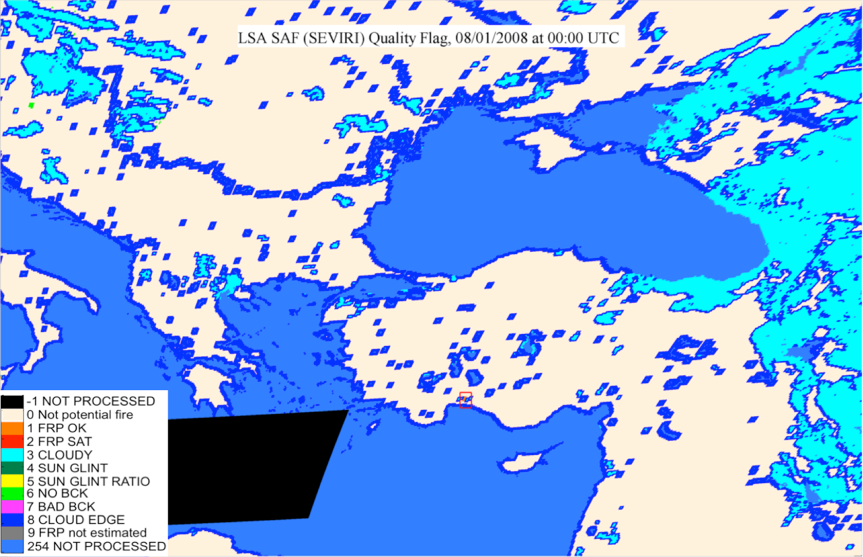
LSA SAF FRP-PIXEL (SEVIRI) Quality Flag map, in the red box the detection of a large fire in the Antalya province.
Active fire product provides the location of a hot spot and the other important fire parameters with a view to obtain relevant information on the detected hot spot. Among these parameters is the fire's intensity, expressed in terms of Fire Radiative Power1.
The most used active fire products have been traditionally based on polar-orbiting sensor data, mainly thanks to their high spatial resolution and acquisition at a global scale. And, at this moment, the MODIS fire product is a consolidated product and a reference for global Earth observation.
The MODIS product detects fires in 1km pixels that are burning at the time of overpass under relatively cloud-free conditions using a contextual algorithm, where thresholds are first applied to the observed middle-infrared and thermal infrared brightness temperature and then false detections are rejected by examining the brightness temperature relative to neighboring pixels (Giglio, L. et al. 2003).
A detected fire does not necessarily mean that the entire area represented by the 1km pixel is on fire. A detection may be the result of intense fire activity covering a small fraction of the pixel area or fire activity occurring over a broader area. Fire detection omission/comission errors may occur due to input data anomalies, limited satellite observation conditions, and/or potential algorithm limitations.
The Visible Infrared Imaging Radiometer Suite (VIIRS) sensor was launched aboard the Suomi National Polar-orbiting Partnership (NPP) satellite at the end of 2011 and became operative in 2012. It provides similar measurements to MODIS at higher resolution.
Near real time fire detection and characterization products are available for MODIS and VIIRS:
But the most important limitation of polar satellite systems, with regard to the needs of continuous and in-real- time monitoring of wildfires, is their infrequent overpasses, varying inversely with the spatial resolution of the sensor.
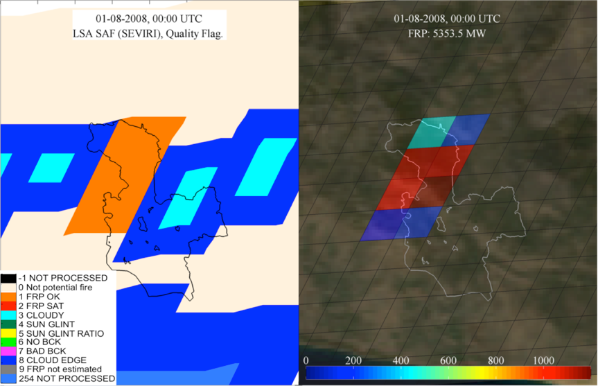
LSA SAF FRP-PIXEL (SEVIRI) Quality Flag map in the red box surrounding the Antalya fire (see Fig. above). And respective FRP estimated over the pixels flagged as potential fires (FRP OK).
In fact high temporal resolution, is essential for early detection (less time for a fire to burn before an overpass), detection of short-lived fires (a fire may extinguish before an overpass takes place), tracking a fire's evolution over a series of image times, and increasing the opportunities to see a fire under changing cloud conditions.
In this respect only geostationary systems with their inherent high temporal resolution can be helpful; the Spinning Enhanced Visible and Infrared Imager (SEVIRI), on board the geostationary Meteosat Second Generation (MSG) satellite, allows for observations over Europe every 15 minutes (or every 5 minutes in the Rapid Scanning Service mode at the expense of coverage).
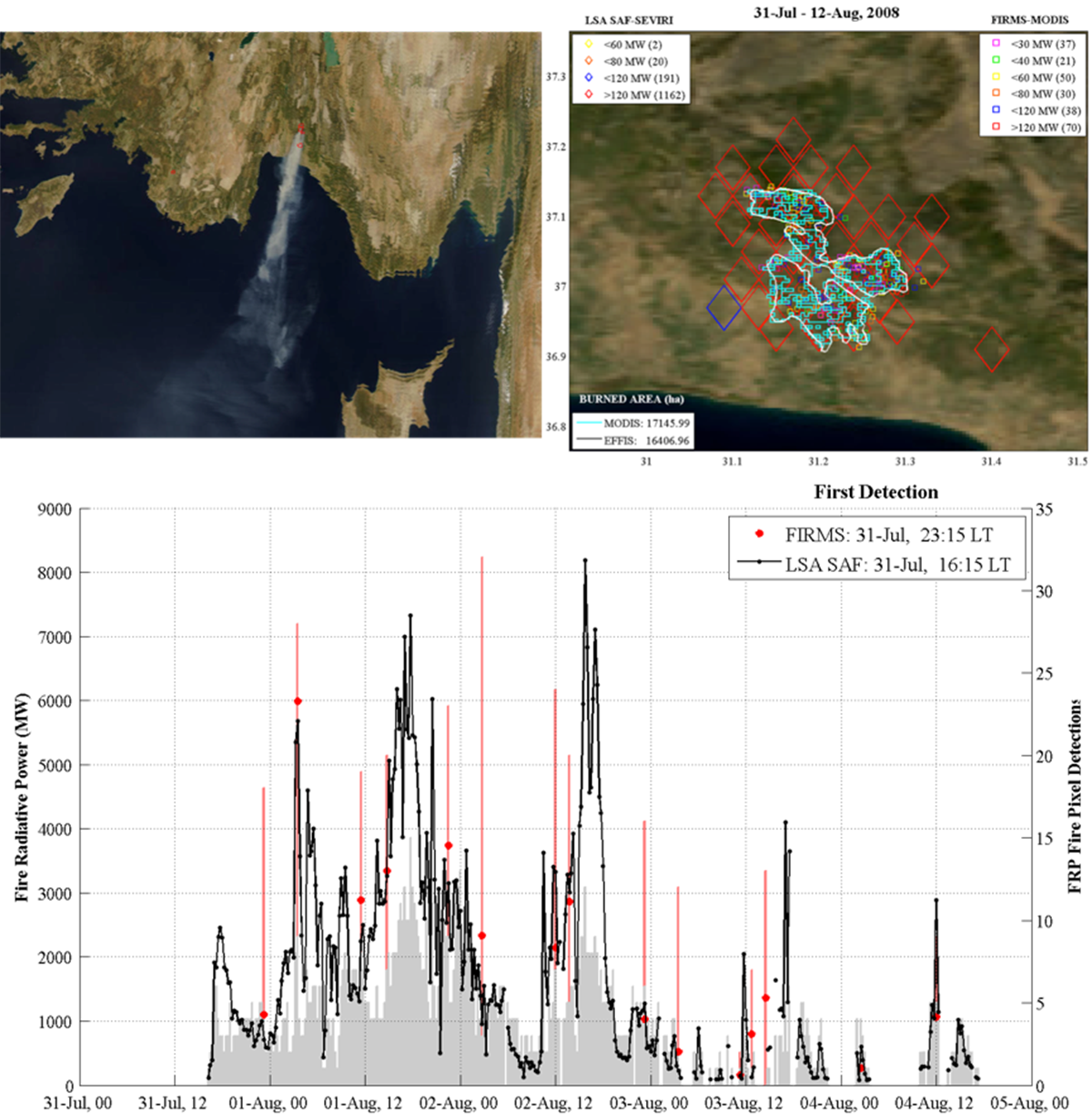
Large fire observed over Antalya during summer 2008 with SEVIRI (LSA SAF) and MODIS (FIRMS) based active fire products. MODIS burnt area is also depicted.
Despite its coarse spatial resolution (~4 km over Southern Europe) recent studies demonstrated that SEVIRI data can be used operationally to assist the detection of fires by improving the reliability in fire announcements (Laneve & Cadau, 2006; Georgiev & Stoyanova, 2013) and allowing real time fire front monitoring in the Mediterranean region. The role of SEVIRI is especially useful as the fires increase in number and size (Sifakis et al. 2011).
Since the launch of Meteosat Second Generation in 2002, a number of studies have used different algorithms to study active fires with SEVIRI observations (e.g. Calle et al., 2009; Amraoui et al., 2010). This has led to certain other routinely generated SEVIRI active fire products being available. These SEVIRI-based products include:
Generally the mentioned SEVIRI based fire products produce two main outputs:
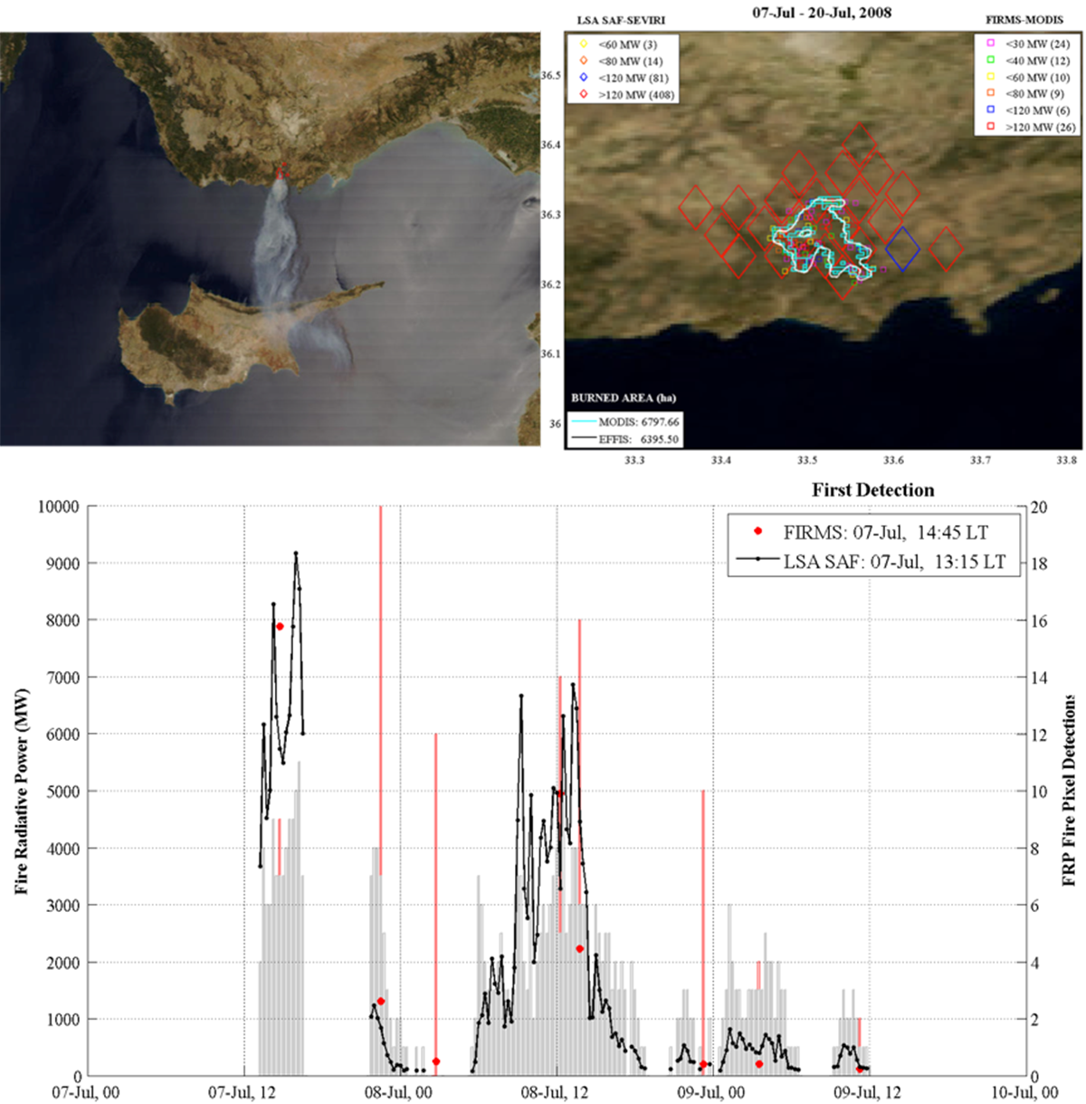
Large fire observed over Mersin during summer 2008 with SEVIRI (LSA SAF) and MODIS (FIRMS) based active fire products. MODIS burnt area is also depicted.
Since the threshold of detectability of a fire is not only dependent on the instrument but also a function of the pixel area, geostationary sensors have a higher minimum FRP detection limit (typically > 40MW) than polar orbit instruments (e.g. ~8MW for MODIS). They therefore do not observe the lowest FRP component of the fire regime ( Roberts et al., 2005; Freeborn et al., 2014
1 Fire Radiative Power (FRP) is a measure of the radiant energy liberated per unit time from burning vegetation via the rapid oxidation of fuel carbon and hydrogen. It is the best satellite based indicator of the energy of the fire and its growth potential.