Burnt area maps derived from satellite imagery are widely used to investigate the causes and consequences (such as pyrogenic emissions) of vegetation fires. Two products with daily resolution are currently available:
For both the fire scar detection is based on rapid drops in vegetation-related reflectance of the area affected by the fire burnings.
Major differences have been reported, however, between these fire scar products, mainly on account of overestimation of the burnt area by the L3JRC (Chang and Song 2009, Giglio et al. 2010).
The most widely used is definitely the MODIS one. For this, the mapping of burnt areas is based mainly on the 250 meters bands, although the MODIS bands at 500 meters resolution are also used, as they provide complementary information that is used for improved burnt area discrimination.
This type of satellite imagery allows detailed mapping of fires of about 50ha or larger. Although only a fraction of the total number of fires is mapped (fires smaller than 40 ha are not mapped). The analysis of historical fire data has determined that the area burnt by wildfires of this size represents in most cases the large majority of the total area burnt. On average, the area burnt by fires of at least 40 ha accounts for about 75% of the total area burnt every year in the Southern Europe (JRC, 2011).
Since the launch of SUOMI-VIIRS, a VIIRS Burned Area product has been developed, that will continue in a consistent manner the 14-year MODIS record of global mapping of fire burned area.
Due to the data and analysis requirements associated with the MODIS science processing algorithms to yield reliable burn scar products, the burn scar data are not available in near real-time. Currently, MODIS burn scar data are compiled by the Active Fire Mapping Program as monthly datasets are typically available approximately 10 days after the beginning of each month. The burn scar data are provided as monthly GeoTiff and KMZ products for the specified geographic regions.
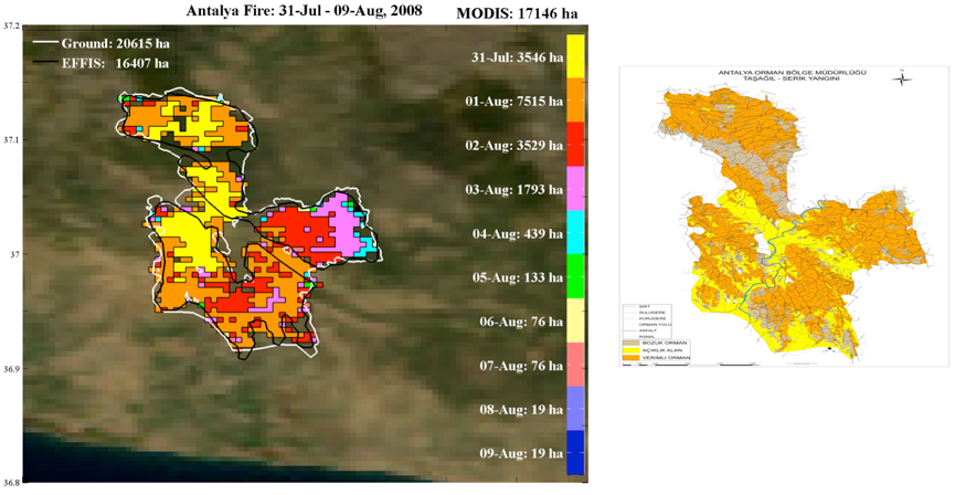
The large fire recorded in the municipalities of Tasagil and Akbas (Antalya), as viewed by the MODIS 500m burned area collected between July 31 and August 9, 2008 and coloured by day of the year they were detected. The fires occurred in areas forest, mainly dominated by Turkish red pines (Pinus brutia) and affected 171.5 km2 according to these data. Also shown as a white outline the ground reported burned area, of around 206 km2 and, as a black outline, the 2008 burned area perimeter extracted from EFFIS that encompass 164 km2. The background is a MODIS Blue Marble image (500m resolution).