Fire Danger is a relative index of how easy it is to ignite vegetation, how difficult a fire may be to control, and how much damage a fire may do. Early warning of these conditions allows fire managers to implement fire prevention, detection, and pre-suppression action plans before fire problems begin. Fire danger information is often enhanced with satellite data, such as hot spots for early fire detection.
Normally, fire danger rating systems provide a 4- to 6-hour early warning of the highest fire danger for any particular day that the weather data is supplied. However, by using forecasted conditions from advanced numerical weather models, extended early warning (i.e., 1-2 weeks) can be provided. This extra time allows for greater coordination of resource-sharing and mobilization within and between countries.
Fire danger rating research has been ongoing since the 1920's, resulting in operational fire danger rating systems being available for about 4 decades in Canada (Stocks et al., 1989), the United States (Deeming et al., 1977), and Australia (Luke and McArthur, 1978). Numerous other weather-based systems and indices have been developed worldwide, although the Canadian Forest Fire Weather Index (FWI) System remains the most widely used fire danger rating system internationally.
FRM product from the LSA SAF combines information from Numerical Weather Prediction (NWP) models - in this case the operational forecasts from ECMWF - and vegetation state from SEVIRI to derive forecasts of the risk of fire for the European region. The rationale is to provide the user community with information on meteorological risk that will allow adopting the adequate measures to mitigate fire damage. The FRM algorithm computes the set of components of the Canadian Forest Fire Weather Index System (CFFWIS; van Wagner, 1987) for the following 24h, 48h and 72h. These indicate prognostic levels of fire danger over the European area.
However, a single fire danger value has different meaning (in a fire management context) in different parts of the world because of differences in the local fire regime. For that reason, there is additional value in understanding fire danger in relation to the "local" fire regime, which includes the influences of fuel, ignition sources, climate, fire management/suppression policy, etc.
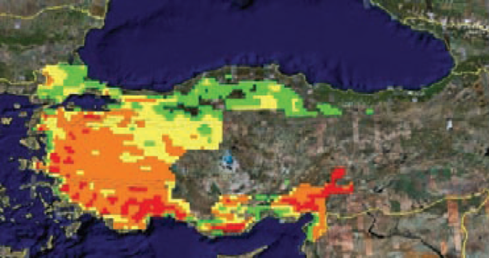
Fire danger level in Turkey during summer 2008 (EFFIS 2009).